Collective Valleys: Reclaiming Bisri’s Contested Landscape

Figure 1: Dam construction in Lebanon’s valleys poses a major threat to the environment; Source: Photography by author and Google Earth Snapshots.
On November 16th 2019, a dozen tents were set up in the pine forest of the Bisri Valley, forming a sit-in to protest the construction of the Bisri Dam. Since the end of the Civil War in the 1990s, Lebanon witnessed a rapid trend in privatized and polluted landscapes across its territory.[1] Sectarian borders inscribed the physical landscape as different political factions claimed their territories across mountains, valleys, and the coast, where water became one of the many natural elements to be privatized. By using fear-based narratives on the current water crisis in cities, politicians have been advocating for an outdated, centralized, and debt-ridden national dam strategy. From illegal extraction along the coast to concretizing rivers in the mountains, a trend of corrupt water infrastructure facilitated the monopoly over water across the valley section.
The Bisri Dam was first proposed in 1953 by the US Bureau of Reclamation and re-initiated by the Lebanese Government in 2012. The dam, part of the World Bank’s “Greater Beirut Water Supply Project” (GBWSP),[2] is planned to be located around 35 kilometres southeast of Beirut and aims to provide 125 million m3 of water to over 1.6 million people in the Greater Beirut and Mount Lebanon area, making it one of the largest mega-dam infrastructure projects in Lebanon. After a long-term effort of activists and campaigners supporting the “Save the Bisri Valley Campaign”, the project was halted in 2020 when the World Bank decided to withdraw its $474 million loan.[3]
This essay studies the rise of protests in the face of a series of dam infrastructure projects in Lebanon and argues that dams have been used as political maneuvers for the private monetary and status gain of the ruling class. By tracing the history of water infrastructure planning in Lebanon, the geopolitical influences, and the impact of dam building on the environment, this research investigates the ways in which dams have disrupted local ecologies and exacerbated existing social tensions. The essay unfolds the series of events that led grassroots mobilization efforts to expand, and encouraged citizens to begin questioning the corrupt systems that shape their environment. The process of protest allowed for a shift from a political dispute over power into a wider narrative of environmental and socio-cultural concern. Consequently, an alternative way of perceiving infrastructure emerged through collective acts of reclaiming and reconnecting to the landscape.
A History of Lebanon’s Hydraulic Mission
Historically, dam infrastructure in Lebanon followed a modernization approach that focused on the expansion of political power and private monetary gain. Beginning with the French Mandate’s vision of capitalizing on water abundance, followed by the US Bureau of Reclamation’s (USBR) foreign river basin development projects, and most recently Lebanon’s confessional system of dividing resources, water management has often represented underlying geopolitical power struggles. The story of dam infrastructure begins under the French Mandate (1920-1943), when Lebanon’s water abundance was perceived as a missed opportunity for water collection, since water being drained into the sea was viewed as a waste. In his book, Silenced Rivers, environmentalist Patrick McCully draws on the historical ideology of dams bringing “powerful and capricious natural forces under human control”. He states that the most common perception of an undammed river is viewing it as a wasted resource, leading to politicians and developers believing that “a river has no value unless it is in some way controlled (and not just used) by humans”.[4] This ability to reorganize the natural and social environment demonstrated the strength of the modern state to become, as Timothy Mitchell states, a “techno-economic power”.[5] Lebanon carried forth this narrative after its independence in 1943, where the hydraulic mission for dam building formalized into newly institutionalized water authorities. The United States’ Point IV development mission was launched in the 1950s by the USBR and aimed to bring modern river basin development approaches to underdeveloped countries including Lebanon which was seen as a strategic opportunity for US foreign policy during the Cold War.[6]
Building on earlier studies conducted during the French Mandate on the Litani River basin, which runs north-south along the east side of Mount Lebanon, the USBR expanded the project by establishing the Litani River Authority (LRA). This new governmental body was an expansion of the Tennessee Valley Authority (TVA), the leading federal corporation for dam building in the US.[7] The Litani River development project consisted of hydroelectric dams that could also cater for irrigation purposes. One of its largest components was the Qaroun reservoir, built in 1965. Although the project aimed to supply water within the river basin to areas further south of Lebanon, political concerns on transferring water closer to the Israeli state arose, which ultimately led the Bureau experts to propose diverting the water away from the southern region and instead move towards the north to avoid political conflict. The initial aim of working through a comprehensive basin development within the Litani watershed was lost as the project’s focus became a singular mega-dam reservoir in the Bisri Valley, bringing forth the Bisri Dam project. In this scheme, the water collected at the Qaroun dam was proposed to be diverted across the Lebanon Mountains, and into the Awali watershed through a diversion tunnel going against gravity- the 15-kilometer-long Bisri Tunnel. The source of water now shifted to be supplied from the Bisri Dam, to provide water for Beirut residents and to irrigate the coastal plains in the suburbs of Beirut.
While officials did not proceed with the scheme due to failures in construction,[8] the proposal re-emerged in the early 2000s by the Council for Development and Reconstruction (CDR), a governmental organization established in 1977, two years after the destructive start of the Civil War (1975-1990). The CDR aimed to assess infrastructural needs and allocate international and Lebanese aid for reconstruction. Despite the efforts in rebuilding the country post-war, Lebanon succumbed to a political structure that was an extension of the political warring sects, where war militias turned into religious-political organizations, further exacerbating Lebanon’s neoliberal policies.[9] Large-scale development projects were divided among ministries related to the different sects, such as the Free Patriotic Movement, the Future Movement and the Progressive Socialist Party, to create an equal distribution of properties among the groups. Aihwa Ong proposes the term ‘post-developmentalism’ to describe a “dispersed strategy that does not treat the national territory as a uniform political state”. She further emphasizes how “market-driven logic induces the coordination of political policies with the corporate interests, so that developmental decisions favor the fragmentation of national space into various non-contiguous zones”.[10] While the sects attempt a balancing act of ownership over geographical or economic assets, they instead create zones of various levels of development, further weakening the possibility of a cohesive plan across the territory. Developing infrastructure becomes a decision that benefits specific zones, their affiliated political groups and monetary gain for corporations that can be external funders or politically affiliated contractors, further emphasizing the infrastructural object as a political project. As Brian Larkin describes infrastructure projects as representations of state power to citizens, he notes that these projects carry a poetic meaning where the “form is loosened from its technical function”. These symbols of power overshadow the existing terrain they are impacting, and attribute a new meaning to the landscape, in which the land becomes a monetized zone that attracts budgets as “arbitrary symbolic acts”.[11] In the case of Bisri, the dam emerges as a symbolic act of solving the water crisis in Lebanon’s capital city, despite adding a massive debt to the state’s already looming economic crisis at the time.

Figure 2: The Emergence of Dam Building and the Rise of Protests in Lebanon. Drawing by author.
Political and Environmental Contestation
The “Save the Bisri Valley” campaign was launched in 2017 when a few environmental activists, with prior experience in an environmental movement against dam building in Lebanon, came together to initiate a call for action against the Bisri Dam. After unsuccessful attempts to redirect the government in past dam projects, the cofounder and coordinator, Roland Nassour, along with environmental activist Paul Abi Rached, began to voice their concerns directly to the main financier- the World Bank. The Bank’s determination on proceeding with the project and viewing it as a sustainable solution for the water crisis, highlighted the bigger challenge of dealing with hegemonic infrastructural systems. The political landscape of the Bisri project involves multiple scales of power, ranging from local municipalities to national governmental institutions, ministries, and this international financial institution. The confessional power-sharing structure that emerged in post-war Lebanon with the 1989 Taef agreement created a muhasasa system that allocated resources and public official appointments to different political sects.[12] This allowed for individual political agendas to intersect with the public sector, causing most nation-wide decisions on infrastructure to be based on dividing ownership of resources between the political factions, rather than planning for sustainable and resilient infrastructure and environmental systems.
Dams became political maneuvers for territorial expansion, monetary gain, and electoral support. Even though almost every political party has a dam project on its agenda, the Free Patriotic Movement (FPM) has been leading three mega-dam projects across the territory since 2012. Unsurprisingly, the FPM party was also allotted both the Ministry of Environment (MoE), the main stakeholder of the Bisri project, and the Ministry of Energy and Water (MoEW), the organizational entity responsible for assessing the ecological impacts. The implementing agency, CDR, is also partially controlled by FPM along with the Future Movement, Amal Movement, and the Progressive Socialist Party.[13] The overlap between sectarianism and public services, along with the continuous involvement of the World Bank, further portrays the long-lasting timeline of top-down politically motivated dam infrastructure. The domination of rivers illustrates one way of how the control of nature and the control of people are linked, especially in the case of large dams operating with a single bureaucratic entity that can give or deprive access to water.[14]

Figure 3: Actor-Network Diagram of the Bisri Dam (left), Bisri Dam Project re-drawn from original World Bank image (right). Drawing by author.
An Interdisciplinary Environmental Campaign
The mobilization efforts as part of the anti-dam campaign took different forms: starting with the use of social media, the campaign created a Facebook page that circulated information on the environmental threats of the Bisri Dam, shedding light on the corruption in water management regimes, and proposing sustainable alternative solutions for water collection. The campaign attracted concerned citizens and experts from different disciplines from these awareness raising methods online, sparking fierce debates on the Bisri Dam. Environmental activists, archaeologists, hydrologists, lawyers, designers, planners, and local residents joined the conversation on the preservation of the ecological and cultural assets of the valley, and on addressing the water crisis at a national scale. The process of protest gradually grew into an interdisciplinary movement to reclaim the right to these landscapes.
The campaign was able to expand the debate beyond the suitability of the dam itself, into a larger dialogue on planning water systems and preserving cultural landscapes across the national territory. Shifting the narrative from a political dispute on ownership into an environmental and socio-cultural concern, the movement sparked debates that were not previously present. The boundaries between citizens, academics, experts, activists, and politicians began to blur as the Bisri project was investigated and critiqued through different lenses.
A scientific approach was first taken to highlight the shortcomings of the infrastructural project. Geologically, the Bisri Dam is located within a seismic active zone, increasing the risk of earthquakes.[15] Two thirds of Lebanon is composed of porous karstic rock formation, allowing water to seep through. Hence, the construction of the dam will need an impermeable cement base, which will triple the cost of the project and require the ‘cementation’ of an entire valley. Environmental activists also mapped out the extent of ecological destruction that the dam reservoir would impact, which included wiping out around 150 hectares of agricultural land and 82 hectares of pine forests.[16] While the Bisri Valley is zoned as a protected regional environmental area by the National Physical Master Plan of the Lebanese Territory (NPMLT), as well as a natural site to be protected by the Ministry of Environment (Article 131/1998), the National Water Sector Strategy (NWSS) directly placed the Bisri Dam within that protected zone. River valleys in general were zoned as important ecological areas to be protected in the NPMLT, commissioned by CDR in 2012. At the same time, however, the NWSS proposed 22 dams on Lebanon’s 17 perennial rivers. The contradiction between ecological preservation and water management reflects the mismanagement between the two entities- the Ministry of Energy and Water and the Ministry of Environment. The gap between this territory-masterplan and infrastructure projects is due to the lack of planning at the district scale, where 85% of Lebanese Territory remains unplanned.[17] With the lack of multi-scalar planning, large projects are implemented without an elaborative interdisciplinary assessment, where infrastructure is now devoid of socio-cultural and environmental considerations.

Figure 4: Contradiction between the National Water Sector Strategy (NWSS) and the National Physical Masterplan of the Lebanese Territory (NPMLT): the National Water Strategy overlaps with ecological corridors to be preserved. Drawing by author.
Investigating the feasibility of the dam grew into a re-questioning of the territory’s masterplan, and mapping out the mismanagement and contradictions across government agencies. The campaign went beyond the environmental fight and grew into a decentralized effort to break down the network of corruption, linking this goal to the multiple ways in which cementing the valley is also an environmental, cultural, and economic destruction.
At the same time, archaeologists began to uncover the historical and cultural significance of the Bisri Valley, looking beyond the nature of valleys as being hydrological connectors from Mount Lebanon to the Mediterranean Sea. Archaeological temples, chapels and other remains dating back to the Persian, Ottoman, Byzantine, Roman, and Hellenistic periods drew a historic route from the sea to the mountains, further emphasizing Bisri’s significance within the Awali River, historically called the ‘Eshmoun Valley’ in Phoenician times. Data from Lebanese-Polish surveys conducted between 2004 and 2008 was retrieved, and identified 78 archaeological sites along the Awali River Valley, of which 27 were located within the proposed dam reservoir area. These surveys described the cultural importance of the valley: “The valley, which reaches the sea a few kilometers north of ancient Sidon, may have served this important Phoenician city as a natural economic hinterland. It was likely important also because of the sacredness of the river itself, as witnessed by its ancient name, referring to the god Eshmoun in the Phoenician period and to Asklepios during Greco-Roman times.”[18]
A Roman temple that sits at the confluence of the Awali River on the Bisri agricultural plain, became a symbolic representation of the cultural landscape of the valley. A lush landscape hosting a wide array of agricultural practices, from wheat and vegetable fields to orchards and olive groves, was a source of income for landowners and local residents.
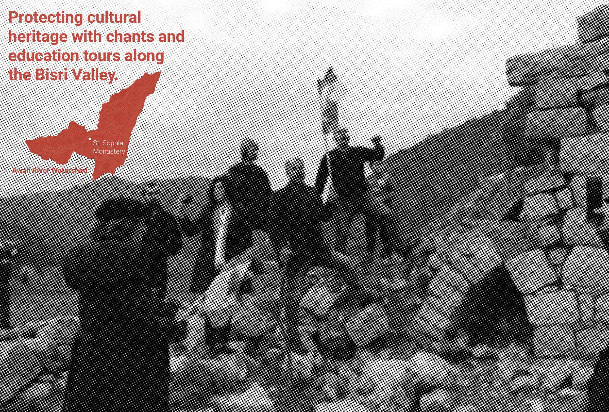
Figure 5: Protesting in the Bisri Valley; Picture and graphics by author.

Figure 6: The cultural landscape of the Bisri Valley; Drawing by author.
In October 2020, a special publication on the Bisri case produced by Legal Agenda,[19] a nonprofit research and advocacy organization, convened diverse voices and narratives around the Bisri Valley. The organisation positioned itself as a supporter for the anti-dam movement and was successful in featuring scientific and academic articles contesting the dam, while also highlighting the stories of the locals’ relationship to the landscape. Other organizations and news outlets joined the movement by collecting evidence and interviewing concerned experts and citizens. Academics also sent open letters to the government and the World Bank pleading for the cancellation of the project.
Protests on the Ground
In 2018, the campaign began to protest directly in the contested landscape, starting with organising hiking trips to the valley. Participants walked through historic paths and visited archaeological ruins. Getting acquainted with the landscape was important to build a connection between citizens and their environment. The visits to the valley naturally became protests as people developed a connection to the land and felt the need to protect it. More people started joining the movement across the country, and with the diverse ways of protesting in the valley, people found their own ways in identifying with the land. Hiking trips morphed into marches, sit-ins with banners and demands addressed to the government and the World Bank. While the protests were done peacefully, tension started to escalate as CDR put up barriers and a checkpoint at what became the ‘entrance’ to the valley in February 2019.[20] This increased the activists’ will to proceed with their movement and to even break the physical borders of the project.
The protests spread even further as concerned citizens took to the streets of Beirut and held sit-ins at the headquarters of the World Bank and CDR, while news coverage streamed the events. More supporters joined the cause and the protests became frequent in Winter and Spring of 2019. The escalation of protests led to increased security measures by the CDR and affiliated political factions. For instance, during one protest, activists were faced with around 100 members from the Army and the Internal Security Forces that blocked the road leading to Bisri. A scene that quickly mimicked a battlefield, armed forces were seen entering the valley with their vans to counter the protests and guard the land, which became a symbolic image of Lebanon’s contested landscapes.[21] Violent reactions by political groups increased where the co-founder of the campaign was physically attacked during a heritage site visit at the Roman temple. The incident caused the campaign to pause its efforts for a short while. During this time, violent acts on the land proceeded to demonstrate the initiation of the project, where a grove of pine trees were chopped down by the contractor, followed by an attempt to uproot the historic Monastery on site.
The process of endless ecological and cultural destruction, paralleling a continuous state of protest, became a battle for different visions of the landscape. The way in which people reclaimed the land introduced nuances within this fight, where the terms of ‘anti’ and ‘pro’ dam dissolved into discussions and debates, where political discussions merged with environmental and economic considerations among citizens and experts. Although political parties involved with the project maintained a divisive rhetoric, the pressure that public activism placed on the government paused and slowed down the process of implementation, giving more time for mobilization groups to ground themselves within the valley.
Building Narratives, Breaking Borders
Like most administrative borders in Lebanon, the geographical boundaries of districts often overlap with rivers, increasing political tension when it comes to water development. The Awali River is the official border between the Chouf (affiliated with the PSP) and Jezzine (affiliated with FPM) Districts. The Bisri Dam, located at that division between these two areas that were in conflict during the Civil War, reignited the sectarian divide and resurrected the ghost of the war in people’s minds. Hence, questioning the suitability of the dam translated into a defiance against the political sect and undermining the capabilities of the governmental officials. Any possibility of stopping the dam project was also a looming fear amongst the two PSP and FPM sects, since the 12km2 of the expropriated area for the reservoir was now state-owned and its future development remains uncertain. Power struggles over land were evident in February 2020 as the PSP leader shifted his position to oppose the dam and alternatively propose it to be a nature reserve in order to reinstate his power when he was in a politically weak position during the formation of Lebanon’s new government. On the one hand, the FPM party has been leading the dam projects across the country, and on the other the PSP affiliated family has been the oldest feudal family with the largest ownership of nature reserves in the country.[22] These two polarized futures for the land, one of exploitation and extraction and the other as preservation, stem from the same thread of hegemonic and top-down planning where landscape is treated as a blank slate.

Figure 7: The contested landscape of the Bisri Valley; Drawing by author.
The biodiverse and hybrid landscape of the Bisri Valley was diminished to either being submerged by a water reservoir or shielded with a ‘green cover’. Mona Fawaz discusses the relationship between landscape and property in which she claims that the ‘ownership model’ used in land-use planning limits possibilities over natural and built landscapes, where these ‘propertied landscapes’ are uncritically represented in the form of “gridded, geometric forms, each of which is ascribed to a well-identified user”.[23] The debate on the future of the Bisri Valley essentially does not expand beyond the physical boundaries of the expropriated parcels, and remains within a politically constructed imaginary. The planning process, then, does not incorporate possibilities for the land that could cater for the surrounding socio-cultural and environmental contexts, but rather is diminished to a strategic assessment of how to utilize the landscape for territorial expansion and political power, further privatizing the landscape and limiting alternative types of ownership and value of the land.

Figure 8: Overlapping political and landscape borders of the Bisri Valley; Drawing by author.
These imposed binaries of the valley weakened as citizens built a strong connection to the land. A camp that was managed by a group of locals was established in the pine forest, and lasted around for 40 days during Fall of 2019. Protesting the Bisri Dam accelerated during Lebanon’s October 17 Uprising, where the national scale of protests against corruption in Lebanon heightened the awareness of citizens towards the project.[24] The Bisri case became a symbol for corrupt infrastructure in Lebanon, representing all the contested river valleys, and other landscapes across the country. Bisri became one of the major meeting points during the revolution, and people started chanting for the Bisri campaign in the streets of Beirut and elsewhere. The cause reached national scales allowing citizens to view the valley as their own. Events planned by the campaign in collaboration with other NGOs were held in-situ and the pine forest became a hub for interdisciplinary discussions and debates on environmental planning, water management, and cultural heritage. Archaeological sites became educational spaces of empowerment and celebration. Agricultural fields and the wilderness along the river were collectively cultivated and foraged. A network of citizens at both local and national scales were able to activate the different layers of the valley into a living cultural landscape.

Figure 9: Marching in the Bisri Valley; Photographs by author.
During my own visit to the valley in January 2020, I approached a security guard who was hired by the contractor to monitor the checkpoint. I was curious about his views on the dam as a local resident, and his response started off with confidence in the viability of the dam as it is promised to solve the water crisis in Beirut and possibly cater for the local districts around Bisri. He then expressed confusion about whether or not the construction of the dam is worth the loss it will have on the valley, and ended his thoughts by saying: “Lebanon is filled with nature, there are many other nature reserves and agricultural fields across the country… Why does it matter if they build a dam here? Why protest here?” Larkin points out how the political effect of massive infrastructure projects generates “complicated emotional investments” by citizens and induces “a range of counterintuitive responses and distinct, if ephemeral sensibilities”.[25] In this case, the ‘poetic’ meaning attached to the promised mission of the dam overrides the technicalities and implications the dam will have on the environment and the larger territory. This recurring view of the country as disconnected spaces has been exacerbated by tangible and imagined borders drawn by sectarianism. The division of land amongst political factions facilitated the extraction of natural resources and the privatization of landscapes throughout Lebanon’s history, creating the ideal environment for piecemeal infrastructure developments. In her book, For the War Yet to Come, Hiba Bou Akar examines how the process of planning Beirut’s southern peripheries is an active form of developing sectarian frontiers for individual zones and neighborhoods. For instance, the “planning of peripheries” becomes an act of protection that plays on fear-based narratives, where sectarian lines define the zone in which a religious-political group governs. [26] The overall perceived landscape is defined through these frontiers, and this process of planning exists well beyond Beirut’s boundaries and can be seen as a lack of planning for the national public good, but rather planning for different ‘publics’ within sectarian zones. Consequently, ‘nature’ was also seen as patchwork rather than as an interconnected system shaping the environment in which we live.
A shift in narrative emerged through the protests, where the fight to reclaim the land expanded into a movement calling for systemic change in the political structure shaping the landscape. Jala Makhzoumi describes how 'landscape’ is a process and an outcome that is shaped by the “intangible process of making sense of the surroundings through shared meanings and values.”[27] The river as a border transformed into a common land where people felt that they had agency in shaping and imagining a new vision for landscapes that go beyond the lens of property lines. Reclaiming the Bisri valley through collective marches, chants, camping and foraging, is a process of delineating a common space that goes beyond the sectarian borders of expropriated land. The concept of a Hima emerges as a historical and local idea that stemmed from the collective land use in rural areas. The term signifies a common land that is managed by the community and breaks the idea of a top-down preserved landscape, introducing instead a long-term adaptable relationship between people and their landscape. The idea of a Hima, meaning “protect” in Arabic, differs from a Mahmiyyat, meaning “nature reserve”, where protection is addressed through levels of intervention and ownership.[28] By breaking the perceived and physical barriers of ownership and top-down planning, a new meaning to the landscape was being formed, one that questions how a new hima can begin to exist in the valley.
Landscape as Infrastructure
Lebanon has a large water storage capacity, encompassing around 50 phreatic zones. Water Authorities are yet to plan for the conservation and the management of these aquifers. Instead, their focus has traditionally been on restructuring the administrative structures to host Public-Private-Partnerships (PPS) and build dams. Dam building is a supply-sided water management approach that aims to increase water storage capacity without comprehensively assessing the existing groundwater network. In the case of Beirut, the heavily urbanized city has a surplus of illegal wells due to mismanagement in the water sector, which is leading to aquifer depletion. Rather than treating the mismanagement and pushing for groundwater conservation, the government continues to profit from large-scale water investments. The water crisis in Lebanon has rendered an image of water being a scarce good that needs to be managed, leading to a ‘demand management’ approach, which is portrayed as the only alternative solution. Erik Swyngedouw describes the “discursive production of scarcity” as a strategy enabling the commodification and privatization of water, further facilitating the investment in the expansion of the water-supply side.[29] As a result, infrastructure has become independent of environmental systems, leading to a vicious cycle of reliance on private water sources and dam construction, causing further destruction to the environment.
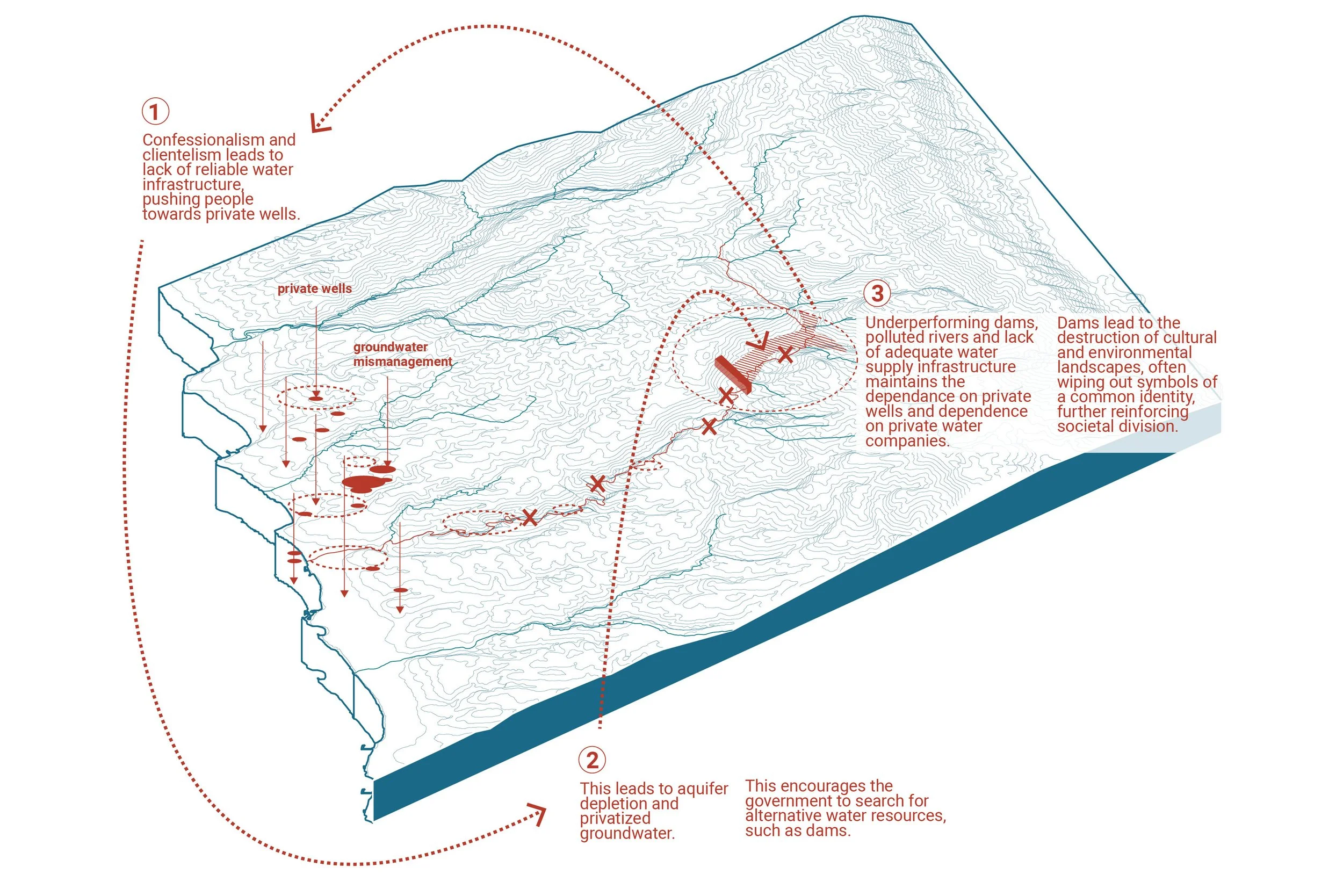
Figure 10: The water infrastructure loop in Lebanon. Drawing by author.
Since the cancellation of the World Bank’s funding for the Bisri Dam, mostly due to the Lebanese Government’s inability to meet the conditions required to resume construction, two debates remain alive. The first revolves around the question of how the water crisis in Beirut and in Lebanon can be solved, and the second centers on the possible futures for the valley. When protesters demand the protection of the Bisri Valley, they are always faced with a question of “what about the water crisis?” This binary emphasizes how these two struggles have become intertwined in a way that forces citizens to decide between ‘nature’ and water. The fact that the Bisri Dam stemmed out of a geopolitical compromise rather than a solution to water management, raises the question of why the capital city’s water shortage should come at the cost of the destruction of the valley, particularly when the water diversion is occurring across watersheds instead of within them. For instance, McCully asserts that “healthy societies cannot exist without healthy watersheds”, further emphasizing the need to look within the boundaries of a watershed[30] to reorganize and adapt to the complex natural systems, instead of taming or controlling them.
The fear-based narrative of water scarcity has instilled in society a ‘state of emergency’, in which Naomi Klein warns about the inclination of this becoming a ‘state of exception’ as she refers to the ways in which “powerful interests exploit public fear to steamroll profitable false solutions”.[31] The fear of Beirut’s water shortage has threatened Bisri’s landscape. The ‘right to water’ in the city and the ‘right to landscape’ in the rural areas are a shared struggle that can strengthen both rather than sacrifice one for the other. The decentralized process of activism in this case study brought to light how diverse viewpoints can create larger citizen involvement and can address several issues within one common goal. The landscape became a framework to address human rights; the right to protect socio-cultural landscapes, and ecological systems.[32]
Landscape also became a tool for restructuring the perceived notion of infrastructure from a centralized object into an interdisciplinary approach of cultural and environmental preservation, policy reform, and small-scale interventions that integrate social benefits. Planning through natural boundaries instead of administrative and sectarian borders is one landscape planning approach using a systems-based thinking. As the campaign shared alternative solutions to provide water for Beirut,[33] new ways of reading the territory became possible. For instance, this could include using the watershed boundary as an organizational framework that incorporates nature-based solutions to water management, which begins to frame hydrology as a multi-scalar system integrated with ecological and socio-cultural corridors.

Figure 11: Watersheds as natural borders. Drawing by author.
Valley of the Commons
The aim of the 2017-2020 grassroots mobilization efforts was to stop the construction of the dam, but the nature in which it happened also started shaping new possible futures for the Bisri Valley and for watershed systems across the country. Collective action on site and through online discussions and debates, sparked new ways of seeing infrastructure as an interdisciplinary system rather than a monofunctional object. The civil campaign’s structure, as Nassour states in his thesis, was loosely organised, making space for a collective identity to emerge and creating flexibility for various voices to join the movement.[34] The continuous discussions between activists and experts with the locals also empowered Bisri residents to reclaim their rights to the land. The ways in which the campaign operated brought the discourse of dam infrastructure to the inclusion of various disciplines, and ultimately expanded ways of seeing infrastructure, beyond a techno-economic power. Currently, Lebanon is still faced with multiple dam projects under construction such as the Jannah Dam, failed dams such as the Mseilha Dam, and other planned dams. While the Bisri Dam is on hold, the topic re-emerges by politicians in situations when they need to reinstate their power. However, the August 4th Blast in Beirut and the economic crisis that the country is undergoing have further revealed the extent of the state’s failure and corruption, which led to a halt in international funding to the government. These conditions have ultimately slowed implementation and planning processes, and have facilitated more NGOs, environmental activists, and community initiatives to form and strategize for long-term goals and projects.
Activism created a unique opportunity to re-imagine the Bisri Valley as a rural common that is a multi-scalar and organic network within the river watershed. This process of “commoning”, as Harvey describes, is “the relation between the social group and that aspect of the environment being treated as a common shall be both collective and non-commodified; off-limits to the logic of market exchange and market valuations.”[35]
As citizens continue to unfold the multiplicity values and systems of the landscape, can they begin to define a new hima operating within a collective watershed alliance? Future possibilities for new ways of governance stem out of a deeper understanding of how our environment naturally operates, and how citizens can coexist with nature. A possible watershed alliance composed of collectives that manage water and natural resources could operate alongside natural systems, further preserving cultural landscapes and allowing emancipatory infrastructural networks to adapt to environmental and political pressures.
Notes
[1] Jala Makhzoumi, Shelley Egoz, and Gloria Pungetti, eds., The Right to Landscape: Contesting Landscape and Human Rights (Burlington, VT: Ashgate. 2011).
[2] “Lebanon Water Supply Project (Bisri Dam)” World Bank, accessed May 1, 2023, https://www.worldbank.org/en/programs/bisri-dam.
[3] Dalal Mawad, “World Bank-funded dam in Lebanon mirrors governance crisis”, The Washington Post, September 2, 2020. https://www.washingtonpost.com/world/middle_east/world-bank-funded-dam-in-lebanon-mirrors-governance-crisis/2020/09/02/9dfdf642-ece3-11ea-bd08-1b10132b458f_story.html.
[4] Patrick McCully, Silenced Rivers: The Ecology and Politics of Large Dams (London: Zed Books, 2001).
[5] Timothy Mitchell, Rule of Experts: Egypt, Techno-politics, Modernity (Berkley: University of California Press, 2002).
[6] Roland Riachi, “Water Policies and Politics in Lebanon: Where is Groundwater?,” International Water Management Institute (2016). https://gw-mena.iwmi.org/wp-content/uploads/sites/3/2017/04/Rep.9-Groundwater-Governance-in-Lebanon_final.pdf.
[7] Chris Sneddon, Concrete Revolution: Large Dams, Cold War Geopolitics, and the US Bureau of Reclamation (Chicago: The University of Chicago Press, 2015).
[8] Sneddon, Concrete Revolution: Large Dams, Cold War Geopolitics, and the US Bureau of Reclamation.
[9] Hiba Bou Akar, For the War Yet to Come (Redwood City: Stanford University Press, 2018).
[10] Aihwa Ong, Neoliberalism as Exception: Mutations in Citizenship and Sovereignty. (Durham, NC: Duke University Press, 2006).
[11] Brian Larkin, “The Politics and Poetics of Infrastructure,” Annual Review of Anthropology 42, no. 1 (October 21, 2013): 327–43. https://doi.org/10.1146/annurev-anthro-092412-155522.
[12] Confessionalism is a unique political regime for Lebanon where the government is formed by a grand coalition consensus among different politicians, proportionally allocating political power among the country’s community sectarian lines.
[13] Roland Nassour, “Environmental Contestation: Planning and Political Change: The Save Bisri Campaign Lebanon” (MA Thesis, American University of Beirut, 2020).
[14] McCully, Silenced Rivers: The Ecology and Politics of Large Dams.
[15] Tony Nemer, “The Bisri Dam Project: A Dam on the Seismogenic Roum Fault, Lebanon,” Engineering Geology 261 (November 1, 2019): 105270. https://doi.org/10.1016/j.enggeo.2019.105270.
[16] Hadi Afif, “The Bisri Dam Project in Lebanon is a Ticking Atomic Bomb”, Beirut Today, July 16, 2019. https://beirut-today.com/2019/07/16/bisri-dam/.
[17] Public Works Studio, “Urbanism and Law: Masterplanning Lebanon and its Impact on People and Places” (2018). Accessed May 1, 2023, https://publicworksstudio.com/en/projects/urbanism-and-law-master-planning-lebanon-and-its-impact-people-and-places.
[18] Krzysztof Jakubiak and Michal Neska, “Eshmoun valley: The eshmoun valley survey, 2004 interim report,” Polish Archaeology in the Mediterranean (2004): 441-446, https://doi.org/10.11588/diglit.42090#0444.
[19] See Legal Agenda issue no. 64: Marj Bisri Fe Qalb Al-Intifaḍa [Marj Bisri at the Heart the Uprising], January 2020, https://legal-agenda.com/wp-content/uploads/Legal-Agenda_Issue-62.pdf.
[20] Nassour, “Environmental Contestation: Planning and Political Change: The Save Bisri Campaign Lebanon”.
[21] Hassan Chamoun, “Inside the Lebanese Campaign to Stop the World Bank-Funded Dam Project,” Global Voices, April 13, 2019, https://globalvoices.org/2019/04/13/inside-the-lebanese-campaign-to-stop-a-world-bank-funded-dam-project/.
[22] Riachi, “Water Policies and Politics in Lebanon: Where is Groundwater?”.
[23] Mona Fawaz, "Planning and the Making of a Propertied Landscape," Planning Theory & Practice 18, no. 3 (2017): 365-84. https://doi.org/10.1080/14649357.2016.1180423.
[24] Roland Nassour "The Struggle for the Bisri Valley," in The Lebanon Uprising of 2019: Voices from the Revolution. ed. Jeffrey G. Karam and Rima Majed (London: I.B. Tauris, 2022), 277–285.
[25] Bou Akar, For the War Yet to Come.
[26] Larkin, “The Politics and Poetics of Infrastructure”.
[27] Jala Makhzoumi,“Unfolding Landscape in a Lebanese Village: Rural Heritage in a Globalising World,” International Journal of Heritage Studies: IJHS, vol. 15, no. 4, (2009): 317–337. https://doi.org/10.1080/13527250902933793.
[28] Ibid.
[29] Erik Swyngedouw, Maria Kaika, and Esteban Orive Castro. “Urban Water: A Political-Ecology Perspective,” Built Environment 28, no. 2 (2002): 124–37. http://eprint.ncl.ac.uk/file_store/production/47331/ACB5807F-FF4E-492B-88AA-505D78042041.pdf.
[30] A watershed is a term used to describe the bounding area along mountain ridges that surround a river, in which water drains downwards from high elevations into the stream and is eventually channelled into the sea.
[31] Naomi Klein, “On Fire,” in All We Can Save: Truth, Courage, and Solutions for the Climate Crisis, ed. Ayana Elizabeth Johnson and Katharine K. Wilkinson (New York: One World, 2020).
[32] Makhzoumi et al., The Right to Landscape: Contesting Landscape and Human Rights.
[33] Roland Nassour, “Beyond Dams: Turning to Alternative Solutions for Water in Lebanon” Al Rawiya, February 19, 2021. https://al-rawiya.com/article-beyond-dams-turning-to-alternative-solutions-for-water-in-lebanon/.
[34] Riachi, “Water Policies and Politics in Lebanon: Where is Groundwater?”.
[35] David Harvey, Rebel Cities: From the Right to the City to the Urban Revolution (London: Verso, 2012).
Author
Joude Mabsout is a landscape architect and urbanist working at the intersection of landscape systems, socio-cultural practices, and infrastructural networks. Currently a designer at Sasaki, Joude works across a range of urban scales; from waterfront development, to campus and city masterplans. Prior to that, she was a research associate at the Leventhal Center for Advanced Urbanism at MIT, focusing on river restoration, climate adaptation, and affordable housing in Istanbul, Tajikistan and Beirut.


